A Weekend at Rainbow Beach Resort on Twin Lakes

Rainbow Beach Resort cabins from the end of the dock
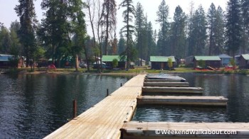
A very close friend of mine has enjoyed an annual vacation at the Rainbow Beach Resort on Twin Lakes In northeastern Washington’s Ferry County for many years.  In fact, when he was a child, his family spent annual vacations at the same resort.

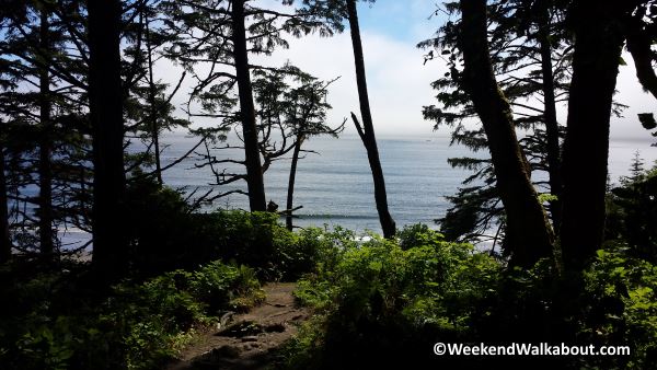
For the past 15 years, or so, my friend has been sharing stories and pictures with me each year upon his return from vacation.  He’s shared about the wakeboarding and tubing behind the boat with his kids.  He’s described his fishing successes, including the best fishing holes on the lake.  Over the years, I’ve come to feel almost like I’ve been there after seeing so many photos of the surrounding landscape, cabins, favorite fishing holes, etc.

Finally, this summer, it worked out that my wife and I were able to join our friends for a few days during the two weeks of their stay.  We chose to make the 4-day weekend trip on our Goldwing.  Travel time was about 4.5 hours each way, so a fair amount of our time was spent on the road.  What better way to do that than on a motorcycle!

The drive from our house began with mostly flat, straight roads.  We were prepared for it to be quite a warm day, so we left early enough that we wouldn’t be on the road when it got too hot.  The last quarter of the trip, as we started climbing into the mountains and came closer to the lakes, we found some nice motorcycle roads – the kind with all the twisties and switchbacks.  We arrived at the resort safely and in good time.

Goldwing parked by our cabin
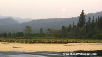
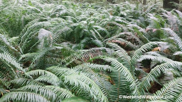
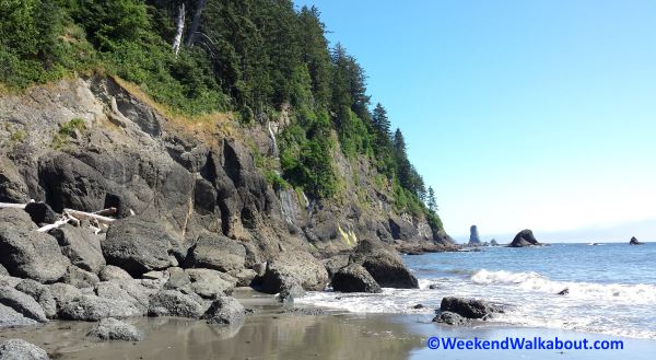
Due to a number of wild fires in northeastern Washington, there was a bit of a haze over the lake and throughout the area.  It was smoky enough that someone with allergies or respiratory sensitivities might have had problems, but Leslie and I didn’t.  A few times, I could feel a bit of a burning in my eyes, but not enough to make me feel that I didn’t want to be there. You’ll notice the haze in some of the photos on this page.

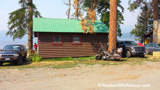
The cabins at Rainbow Beach Resort are small and modest, but when you are spending most of your time on the lake, you really don’t need much more than a comfy bed to sleep in.  My friend brought a small window air conditioner with him and rigged it up in the window above the kitchen sink.  That, along with a number of fans throughout the cabin kept it very comfortable.  I can imagine that without the A/C, it could get nearly unbearable in those little dwellings during the heat of the summer.  As I understand, the cabins used to be shaded a little better, but a number of trees have fallen over the past several years during some storms that came through and brought some very high winds.

Favorite fishing hole
Our favorite bass fishing hole on North Twin Lake.

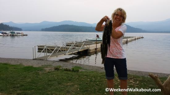
Leslie and I each purchased a one-day fishing license and spent a good part of the day on Sunday out on the boat fishing for bass.  We fished for a few hours in the morning and again in the evening.  From my friends years of experience fishing at these lakes, he’s determined that those times of the day usually provide the most success for catching fish.

Leslie had the most success in catching the most fish.  She caught 5 and I only caught 3, however, I can revel in the fact that I actually caught the biggest bass within our group.

On Monday, our second full day, we took a drive north to go through Kettle Falls and Colville.  It was a fairly quick trip, but we had time to go through some antique stores and thrift shops.  Like most of the shopping of that nature that I’m involved in, I do lots of looking but very little buying.  I find it interesting and enjoyable.

We learned that the weather report for the next day (our departure day) was supposed to bring some afternoon thunder showers.  We had planned to leave around noon, but decided instead to get on the road early so that we might get a jump on the stormy weather.  We managed to catch some rain during the early part of our ride, but nothing severe.  By the time we had made it about half way home, it was actually getting rather warm.  In fact, by the time we got home, it was downright unbearable.  We could have used some cloud cover and even a little moisture to keep things a little cooler.  I’m glad we didn’t wait until noon to leave Twin Lakes.  That’s not to say that I was anxious to get away from Twin.  I’m just saying that an afternoon ride would not have been pleasant that day.

To summarize the time we had, I’d say that the lake and the area was very nice, the cabin was very adequate, but the time we were able to spend with our friends was priceless.

Christine Falls – Mt Rainier National Park

Christine Falls - Mt Rainier National Park
Christine Falls
Popular view of Christine Falls framed by the bridge over Van Trump Creek and the steep rock walls.

Christine Falls is another popular “quick stop” along Paradise Road in Mt Rainier National Park.  After we left Paradise, where we saw Myrtle Falls, and after we had stopped for a few minutes to view Narada Falls, we came to a small parking area where a number of people had pulled off the road to see Christine Falls.  This is another waterfall that you can see from the roadside, but offers the best pictures if you hike down a couple hundred feet to a viewpoint.

This small, but photogenic waterfall is a popular due to its close proximity to the road, but also because the attractively built bridge over the falls and the narrow rock walls create a nice frame for the falls.  This final waterfall on Van Trump Creek falls a total of about 69 feet in two tiers, however, it is nearly impossible to photograph both tiers at the same time.  I’ve seen a photo taken with a wide angle lens from the top of the bridge that shows both the upper and lower tiers.

Upper Tier of Christine Falls
Upper tier of Christine Falls as seen from the top of the bridge.

The entire walk down to the viewpoint and back up to our car was about 350 feet with about a 15 elevation change.  That includes the fact that I slipped past the railing and edged down just a little farther to see if I could get a better angle for my photographs.

The day we were there was a clear sunny day which cast bright contrast and dark shadows in my photographs.  Some clouds would have helped the photography, but I wouldn’t trade it for the pure enjoyment of our trip.

After a few quick photos of Christine Falls, we walked up the road a couple hundred feet to the Comet Falls trailhead, eager to begin the climb to the most spectacular waterfall on this day’s  journey.

Narada Falls Near Mt Rainier

narada-falls
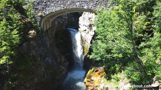
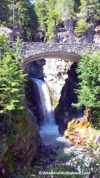
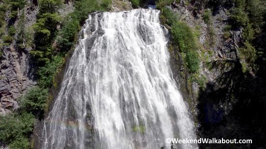
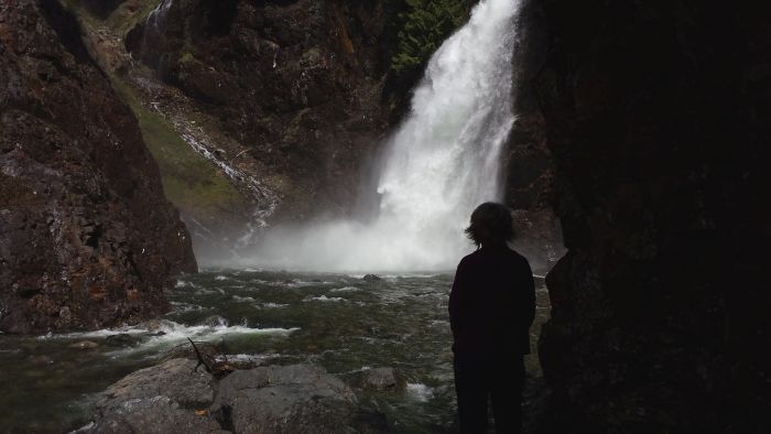
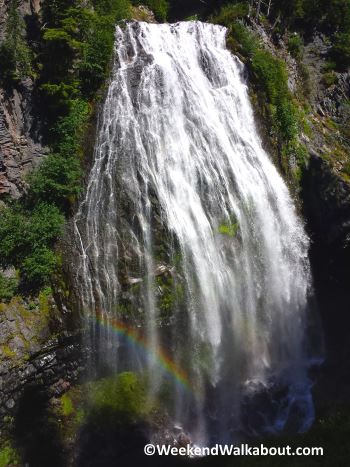
Narada Falls is a very popular roadside attraction in the Mount Rainier National Park.  It is evidenced by a turnoff along Paradise Road E that has the capacity for more than 100 vehicles.  When we arrived to view the waterfall, it was maybe a quarter full, and there were only a handful of people there.  When we returned after our hike to Comet Falls to use the restroom facilities at this site, the parking was packed full and there were people milling around everywhere.  I’m glad we took the opportunity earlier to get our pictures of this gorgeous waterfall.

They have constructed a bridge that crosses the Paradise River that feeds Narada Falls, just above the waterfall. Off to the left of the path are the restroom facilities and to the right is a trail that leads down to a viewpoint of the waterfall. The trail is well groomed and only a couple hundred yards to the viewpoint. I forgot to turn on my gps app on my phone that records the time, distance, and elevation change, but I can say that it was a short, quick, easy hike. I even saw some people much older than I am, and some very small children with their families walking down this trail.

The waterfall drops about 159 feet over a rock wall and spreads out into a wide veil as it falls down the rock face. I’ve read that during heavy drainage, the veil can spread to as wide as 75 feet. It is also reported that during the winter, the waterfall freezes to form heavy icicles and this becomes a popular location for ice climbers.

Narada Falls is about a mile west of where you turn off to go to Paradise. We went to Narada Falls after we had been to Paradise and Myrtle Falls. We just followed the signs as if we were going to Longmire and easily found the Narada Falls Turnout.

Comet Falls – Mt Rainier National Park

comet-falls-first-view
First full view of Comet Falls when the trail opened up to our destination.

Hiking the Comet Falls Trail was the primary purpose of this particular trip to Mt Rainier National Park. Though we had on the agenda to visit Myrtle Falls, Narada Falls, and Christine Falls along the way, Comet Falls was definitely the “Big One”. It would also prove to be the most challenging and the most rewarding.

The scenery was beautiful for the duration. At one point, the forest opened up and gave us an awesome view of Mount Rainier. Mount Rainier is one of those settings that makes a great backdrop to almost any photograph. This one was no exception.

Along the way, we noticed another waterfall that I hadn’t planned to see. At the time I was photographing this waterfall, I didn’t know exactly what we were seeing. After some online research, later, and viewing some photos that others have posted, I believe that we were looking at Van Trump Falls.

As we came nearer to the destination waterfall, we found a rustic footbridge that was on the trail. A sign revealed that we had 200 feet more to hike and directed us over the footbridge.

bloucher-falls
Beautiful multi-tiered Bloucher Falls on the East Fork of Van Trump Creek

Just above the footbridge was another very beautiful multi-tiered waterfall. This was another waterfall that was not on our agenda, and I didn’t know at the time what it was. My research leads me to believe that it was Bloucher Falls. It was another nice gift to us from the Comet Falls Trail.

By now, we were really feeling the pain from the constant uphill climb. Seeing the “200 ft” sign was a real encouragement to us. At about this same point, there were a number of hikers on the way down encouraging us to keep going (we had no intentions of stopping here) as the destination was well worth the struggle.

Arriving at the waterfall felt amazing. Not only could we revel in our accomplishment of having endured a workout well beyond what our training had prepared us for, but the view was breathtaking and the mist from the falls was very refreshing on this warm summer day.

comet-falls-trail-and-mt-rainier
Mount Rainier peeking out from the trees along the Comet Falls Trail.

After several minutes of wandering around the base of the falls and taking advantage of the picturesque setting for a few photographs, we found a large flat rock to sit down on while we settled in for lunch. When we made our sandwiches earlier in the morning, we hadn’t yet decided on specific plans for where we might have our little picnic. But now, the timing was right and the backdrop was perfect for a light lunch under the falls.

A nearly thirty minute break was all the rest we needed and we began our descent back to our car. The nice thing about a one way, two mile, all up hill hike into the wilderness is that the return trip is all down hill. We made much better time on our return.

By the time we returned to our car, we had traveled 4.11 miles in a moving time of 2 hours 15 minutes and a total time of 2 hours 41 minutes. The elevation gain for the hike was about 1250 feet. I suppose it shouldn’t have been all that strenuous, but our conditioning is questionable, so this hike was a good, aggressive workout for us. By the end, I felt like I had accomplished something. I told my wife after the hike that we should do one like this every week. She, basically, told me that I would be hiking alone.

stairs-on-comet-falls-trail
Rough hewn log stairs made this steep part of the trail much safer.
van-trump-falls
Van Trump Falls (or Middle Van Trump Falls) depending on the source.
comet-falls-rock-trail
These large flat topped stones made a good set of stairs for another steep part of the trail.
resting-on-comet-falls-trail
Taking a quick breather along the Comet Falls trail.
comet-falls-200
Only 200 feet more to go. What a relief! We must be out of shape.
footbridge-below-bloucher-falls
Crossing the East Fork of Van Trump Creek on a rough hewn log footbridge.
at-comet-falls
We reached our destination and enjoyed the cool mist from the falls on this warm day in late July.
comet-falls-photo
Kathy took the opportunity to get a close up of Comet Falls. I hope that camera is waterproof.

Save

Myrtle Falls – Paradise – Mt Rainier

myrtle-falls
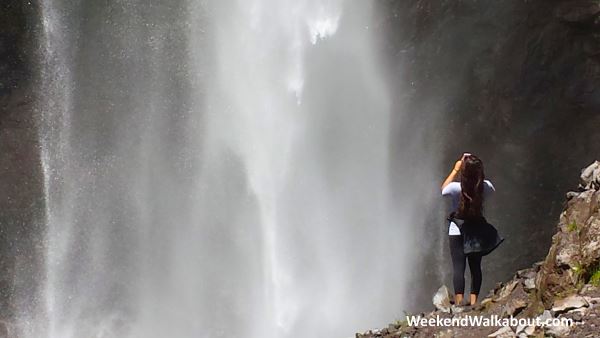
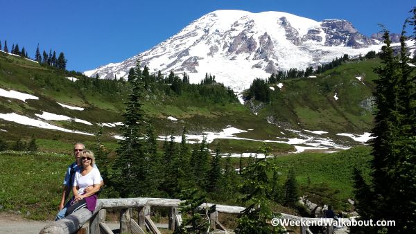
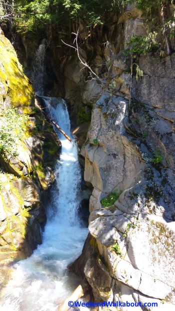
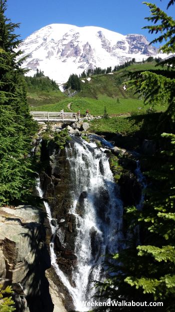
We had researched some of the waterfalls in the Paradise area of Mt Rainier National Park and had determined which of them we would be able to get to in one day.  We selected Myrtle Falls to be our first stop.

By the time we arrived at the Paradise Visitor Center on this Saturday morning in late July, the visitor center parking was already full and we were directed to park on the roadside of the loop around the Paradise area.  Fortunately, we were among the first on the loop, and were able to park on the road just below the Paradise Inn, so we didn’t have to walk far to get back to the visitor center.  An hour later, when we returned to our car, the parking had extended more than half way around the loop, so I’m glad we got there when we did.

The round-trip from our car, to the visitor center, to Myrtle falls, and back to the car was 1.4 miles with a peak elevation gain of just over 200 feet, following the Skyline Trail.  The pathway to the waterfall was entirely paved for easy walking.  The main trail takes you to a footbridge over the top of the falls, but there is a short little side trail that will take you halfway down the side of the waterfall to a viewpoint that allows you to take some very nice photographs of the waterfall.

Myrtle Falls is a pretty little waterfall, with a drop of about 72 feet.  it starts with a wide flow over a large rock wall, but is funneled down to a narrow drop at the bottom.  I loved how the viewpoint was situated to make it easy to photograph the waterfall with the snow covered mountain looming large in the background.

As we were leaving the Paradise area and moving on toward our next stop, Paradise awarded us with one final treat.  We noticed that along the back side of the Paradise loop, cars were stopping and people were jumping out of their cars with cameras.  We weren’t sure of the reason for the commotion, but Leslie spotted it first.  Down in the middle of the loop, about a hundred yards from us, was a black bear and her two cubs.

The bears were just out of distance for a good photo with my Samsung S4 camera phone that I use for all my shots.  I snapped a few photos, anyway, and you can tell that you are looking at some bears.  I think that was the first time I had ever seen a bear in the wild, so we were pretty excited about it.

edith-creek-above-myrtle-falls
Myrtle Falls is part of Edith Creek. This photograph is the creek on the opposite side of the footbridge above Myrtle Falls.
mt-rainier-photo-op
Yes, Paradise is this close to the mountain peak. There are plenty of opportunities for amazing photos of Mt Rainier. The day we were there, the sky was the bluest blue and I don’t remember seeing a single cloud all day.
black-bears-in-meadow
A momma bear and her two cubs were romping around in this meadow about 100 yards from the road. A dslr with a nice, long lens would have been useful right about now.

Strawberry Bay Falls at Third Beach Near La Push

Strawberry Bay Falls

Strawberry Bay Falls was on the agenda for the day.  After having to stop in Sequim for some supplies, then spending some time in Forks, WA to see the “Twilight” scenes, we were running a little late. 

We had originally intended to travel all the way around to Lake Quinault and visit about 4 waterfalls near there.  That part of the trip would have to be held off for another time.

We found the Third Beach trailhead by following our GPS instructions which took us from Highway 101 and onto Highway 110 at Forks, WA. We arrived at the trailhead about 2 miles before La Push. Come to think about it, we never actually ventured on into La Push on this trip. Oh well, something else for another day.

a-little-cool

The hike from the trailhead to the beach is about 1 1/4 miles. It was obvious to me that Leslie was wishing she had brought her jacket. I was wearing a t-shirt and shorts and felt very comfortable.

We made sure that dad and mom didn’t feel like they had to complete every trek that Leslie and I were on, but they were determined to reach the destination.

fern-patch

The scenery along the trail was mostly very green – we were in a rainforest, after all.

trail-to-ocean

Most of the trail was pretty smooth and level, but shortly before we came to the ocean, we began to descent down toward the beach and the trail got a little rugged with rocks and protruding roots.

third-beach-la-push-1

third-beach-la-push

We enjoyed a short walk of about 1/2 mile along a smooth, sandy beach. The weather was very pleasant. A friend of ours who was at First Beach the day after we were here said it was raining so hard, they didn’t get out of the car. I guess we were lucky.

strawberry-bay-falls-from-beach

strawberry-bay-falls-closeup

The waterfall, itself, is rather unimpressive, however, it is unique and interesting as it drops off a cliff and into the ocean. It’s the first ocean falls that I’ve been to. In fact, I don’t think I’ve ever seen a waterfall that drops into any significant body of water.

I think what made this waterfall visit the most interesting was the diversity of landscape through the short hike to the waterfall. I really enjoyed the hike through a rainforest, descending down onto an ocean beach. Who doesn’t like a walk along the beach on a calm day?

Marymere Falls Near Crescent Lake

marymere-falls
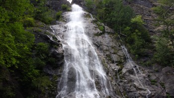
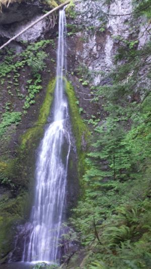
The last waterfall we visited while on our trip to Discovery Bay was Marymere Falls.  It’s located in Clallum County in the north central part of the peninsula just to the south of Crescent Lake and about 20 miles west of Port Angeles.  The trail head is next to the Storm King Ranger Station.

The trail is a round trip of about one and a half miles.  It begins by taking you through a large culvert-like tunnel under the highway, then winds through a clean and well maintained path through the rainforest.  the scenery is exotic and vivid green.  I’ve heard that some describe it as like being in a Lord of the Rings setting.  That might be an accurate description.

The first part of the hike is fairly flat and level.  Along the way, you’ll notice an abundance of ferns and some rather large trees.  You’ll come to two rustic bridges.  The first crosses Barnes Creek, and the second is immediately following the first and it takes you across Falls Creek.  Immediately following the the second bridge, you’ll start climbing stairs and ascending up about 200 feet to a moss covered ravine.

marymere-falls-travel-group
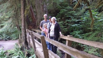
Along the way, the trail splits into a loop that will take you to two different view points for the waterfall.  If you take the left fork, you will first enjoy the lower view point which is directly across from the base of the falls and looking up to the top.  The upper view point provides you with a vantage point that is near the center-top of the 100 plus foot waterfall.

big-tree
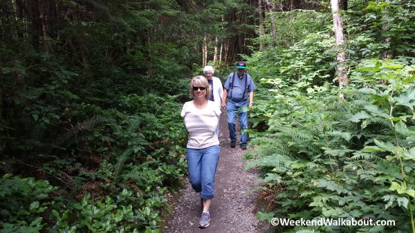
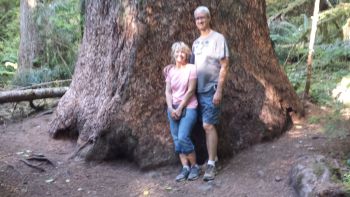
My mom and dad, who are in their late 70’s/early 80’s were traveling with us and were able to make the hike all the way to the lower viewing area.  They elected not to continue the climb to the upper viewing area.  Because the last part of the hike was mostly uphill with lots of stairs, I wasn’t sure that they would continue all the way in to where they could see the falls, but they were troopers – very tired troopers, but they made it.

barnes-creekI can’t begin to describe the feelings and enjoyment that I get from experiencing the beauty of the outdoors that God created for us.  All I can say is that the experience is well worth the short distance to travel and the easy walk to these falls.

falls-creek-bridge

Rocky Brook Falls on the Olympic Peninsula

Rocky Brook Falls on the Olympic PeninsulaAfter leaving Vincent Falls, we continued north on Highway 101 for about another 30 miles to Dosewallips Road, where we left the highway to find Rocky Brook Falls.

Before we turned off to visit Rocky Brook Falls, we made a failed attempt to locate Hamma Hamma Falls using roadsigns and our best guess, since we hadn’t acquired clear directions before the trip, and our GPS didn’t seem to know anything about the waterfall.  I guess that was all right, because we really didn’t have enough time to visit more than two of the four waterfalls that we were knew of along this stretch of 101, so as soon as we realized we weren’t going to easily find Hamma Hamma Falls, we moved on.

Unlike Hamma Hamma Falls, our GPS was well aware of Rocky Brook Falls and we were able to drive directly to the trail head.  I should mention that the Olympic Peninsula Waterfall Trail website gives clear directions for finding this waterfall, as well as all the others that we were interested in visiting.  We just hadn’t spent enough time planning for our adventure as we should have.

For as nice a waterfall as Rocky Brook Falls is, there were surprisingly few visitors.  When we arrived at the trailhead, we found that it was just a wide spot in the road with room for about a dozen cars to pull off and park.  It was only about half full, so we knew that we wouldn’t encounter hoards of other people at this one.

Rocky Brook along the trail to Rocky Brook FallsIt was a short, easy walk along a well groomed trail to get to the falls.  We especially hoped to find waterfalls like this that were easily accessible for my parents who were with us on this trip.  They get around pretty well, but long and rugged trails would definitely hold them back.

Signage along the way warns that water levels can change rapidly, so visitors should be aware of sudden stream flow changes.  One old roughly made and obscure sign didn’t leave me with a seriously threatened feeling.  I have to believe that if there were serious danger, the point would have been made much more boldly.  We watched out, nonetheless.

There weren’t many people at the falls while we were there, but the few that were there were sure a disruptive bunch.  Some were swimming and they had strewn out towels, backpacks, and clothing over the rocks at the base of the falls.  For those of us who were there to get some photographs of the falls, it sure made things challenging.  We had to maneuver ourselves to places where the people and all the junk were outside of the picture frame.  We managed a few decent shots.

It’s estimated that this waterfall is about 150 feet tall.  I wouldn’t call it “spectacular”, but very nice.  It is a nice retreat for a hot summer day.  Because it is so easy to get to, I can’t think of a reason to skip it if you have a little time and plan to be in the area.


Vincent Creek Falls and the High Steel Bridge

Vincent Creek Falls
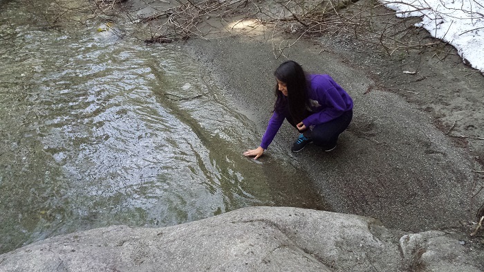
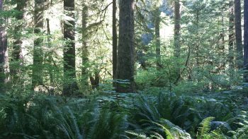
While traveling to Discovery Bay with my Parents, we decided to check on a couple waterfalls that were along the way.  There were four of them between Shelton and Port Townsend that we had identified and we had hoped to visit at least 2 or 3 of them.  I hadn’t done a significant amount of research on any of these falls, but I had downloaded a brochure from olympicpeninsulawaterfalltrail.com before we left on the trip.

The first one we stopped at was Vincent Creek Falls.  When we searched for Vincent Creek Falls on our GPS, we found no applicable result, but then we searched for High Steel Bridge and got a hit.

About 9 miles north of Shelton, we turned onto Skokomish Valley Road and drove west for about another 10 miles before making a right turn onto Govey Road.  This road took us into the middle of nowhere.  I know we were in the middle of nowhere, because the road name turned into a number.  Govey Road become NF-23, and soon after that, we turned onto NF-3240 before parking on a wide spot in the road and walking out onto the High Steel Bridge.

under-the-high-steel-bridge
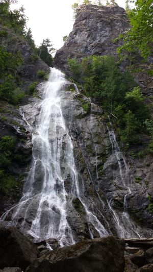
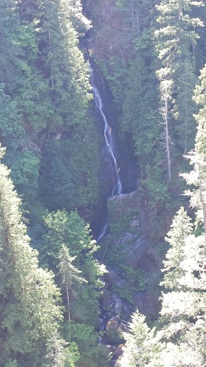
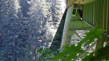
The High Steel Bridge spans across a deep but narrow Skokomish River valley.  From the bridge, you can see the river about 420 feet below.  After walking about half way across the bridge, I looked back over my left shoulder and saw the narrow Vincent Creek Falls dropping about 125 feet over the side of the chasm and then winds down into the Skokomish River.

The word is that the falls are most spectacular in the spring and early summer.  We were here in July, and so the water was not running very heavy.  Even so, the height of the waterfall and the views from the High Steel Bridge made this trip very worthwhile.

Franklin Falls on Denny Creek

Leslie standing and watching the falls

We had to go to Seattle anyway, and had added plans to stop by Snoqualmie Falls along the way.  Why not see if there are any other waterfalls nearby?

Leslie standing and watching the fallsThat’s what we did, and we found Franklin Falls.  It’s on Denny Creek, several miles east of North Bend and just west of the Snoqualmie Pass summit.  The freeway is split through that area, and has created a wide expanse of forest in between.  Part of Denny Creek flows through that expanse.  I’ve driven by there hundreds of times, and never even though about what all might be hiding in there.

We learned that there are forest roads through there that will take you to campgrounds and trail-heads.  When we spoke with forest rangers in Cle Elum before we continued on to Snoqualmie Pass, they weren’t sure we would be able to access the trail-head due to the snow. Making time to stop by there was taking a chance, but we encountered no snow on the forest roads as we drove past the Denny Creek campground and parked at the Franklin Falls trail-head.

Click on the gallery photo below to see a slideshow of some of the pictures we took during our hike.

Kathy tested the water temperature of this recently melted mountain snowpack.

The trail turned out to be a fairly easy one-mile hike. The biggest challenges were a few short areas of remaining snow-pack covering the trail. There were also a couple sections of moderately steep grades. I think anyone, but the most feeble could easily make this hike, and small children may become weary and disinterested, but it wasn’t a great challenge.

I noticed that there is a place a couple hundred yards from the falls, where the trail winds very near the forest road. If you can find that spot on the road, the hike becomes extremely short and easy. That may be the best bet for families with very young children.

It was a little surprising that we had a good media connection on our cell phones and I was able to text with my Dad and Mom and upload images to Facebook while we were hiking.  Dad really likes to stay informed on what us kids are all doing, especially when it’s something exciting, like hiking in the mountains to find beautiful waterfalls.

This turned out to be a beautiful waterfall adventure.  Being an easy one-mile hike, we were in and out of there in a little over an hour.  The trail followed Denny Creek, and we passed a number of smaller creeks that empty into Denny creek, as well as other waterfalls that drop in from the other side of the creek from the trail.

We noticed a number of patches of these pretty yellow trumpet looking flowers.  I texted a picture to my Mom to see if she could identify it.  She recognized the flower, but couldn’t remember what they were called.  Later, we saw a sign at the Snoqualmie Falls trail-head that had a picture of these flowers.  We learned that they are called “Skunk Cabbage”.

If you are ever on your way over Snoqualmie Pass, and have an hour or so to spared, I highly recommend stopping to hike in to see the beautiful Franklin Falls.  Just take the Denny Creek exit and follow the signs to the Denny Creek campground and Franklin Falls.

Have you ever been to Franklin Falls?  Have you been to, or are you aware of any other nice waterfalls near Franklin Falls, or the Snoqualmie Pass summit?  Please let us know by leaving a comment below.